Showing posts with label Fort. Show all posts

Saturday, September 26, 2009

Red Rocks of Arizona

Red Rocks of Arizona


[1] Red Rock State Parks of Arizona features hundreds of such natural red rock formation. These areas have been the background of commercials and Hollywood movies for long time.

Arizona Pictures

[2] Mountain Dwellings

Ancient American Indians in Arizona made their houses in mountains like this. Outside temperature could be one hundred and twenty degrees F. When nearby springs dried up, the waters could be found some eight miles away. Climbing and coming down everyday (no elevators). Preferred for refrigeration and preservation effect, coolness, great views attracted them to live here for a few hundred years. One day in history they all disappeared from here.

Arizona Pictures


[3] A cut away model of above mountain dwellings. The American Indians weaved, made potteries, arts, stored and developed many skills.

Arizona Pictures


[4] Castle living.

Arizona Pictures


[5] Red Rock formation

Arizona Pictures


[6] The natural formation like this and other inspires artist from all over to make their own sculptures, painting
and art objects.

Arizona Pictures


[7] Two color combinations of formation

Arizona Pictures


[8] A day of watching American popular passtime Baseball, in Dodgers Stadium. Los Angeles Dodgers Versus Arizona
To watch a game like this and associated food, drinks, noisemakers and other costs can easily add up more than hundred dollar per person
for a roughly four hours of game. If Hometown team is loosing the watchers leave early.

Arizona Pictures

all Forts in Maharashtra

Forts in Maharashtra

Nowhere in the country would you encounter such a profusion of forts. And such variety. Sited on an island, as at Murud-Janjira or guarding the seas as at Bassein, or among the Sahyadri hills, as at Raigad, whose zig-zag walls and rounded bastions sit like a sceptre and crown amidst hills turned mauve.

Most of the forts in Maharashtra whether up in the hills or near the seas are associated with Shivaji --the great Maratha warrior and an equally great fort builder. Moreover, these forts were treated as mini-cities, such as Panhala, which is now a hill station. The concept of the fort-city was, however, not peculiar to Shivaji alone. The Portuguese who came to India as traders and missionaries, built within a century of their coming, Bassein, a garden city to rival many a European capital.

Pratapgarh
Pratapgarh
samadhi of Chatrapati Shivaji Maharaj
Sinhagad Fort
Sinhagad Fort
Alibaug
Alibaug
Rajgad
Rajgad
Raje
Raje
ShivSamadhi
ShivSamadhi
purandar
purandar
pratapgad
Pratapgad
Lohgad
Lohgad
Janjira
Janjira
Arnala
Arnala

Saturday, September 12, 2009

Trekking spot Ratnagad - Superb Place for Trekkers

Trekking spot Ratnagad - Superb Place for Trekkers

Ratnagad is just 100 k.m from pune

Ratan(Gem) gad fort is a grand fort in the beautiful bhandardara region near Nashik(Nasik), it lies near harishchandragad and kalsubai peak. It lies 20 kms away from the bhandardara dam. Lashing rains for 2 days, extreme windy conditions and some exciting climbs made this one of the most memorable treks in recent times.


<>

trekking spot Chavand - Near Pune

trekking spot Chavand - Near Pune


http://lh4.ggpht.com/_Ig8vhNoZSxA/R3iApI0v_4I/AAAAAAAAA7I/PFgAjHHQxJ8/IMG_0671.JPG

Situated at a height of 3000ft from sea level, the fort houses many a remnant of constructions that take us about 800 years back into the time. The fort is in Pune district, at a distance of 20 km from the city of Junnar. The region at the foothills of the fort contains exotic flora & fauna. It was here that we could spot at least 12 varieties of birds. Village of Chavandwadi lies at the base of the fort.

History

Malik Ahmed founded the Nizam Dynasty in 1485. He was the first Nizamshah who acquired the fort of Chavand after the dissolution of the Bahmani Empire. The seventh Nizamshah was Second Burhanshah. His grandson Bahadurshah was imprisoned here in 1594. Bahadurshah was the nephew of Chandbibi, a renowned
personality from the same period. She played an important role in helping him to achieve the throne.

In 1636 Shahajiraje, father of Shivaji Maharaj, signed a treaty with the Moghals, in which the Moghals got Chavand. Shivaji Maharaj named the fort as Prasannagad",

http://lh6.ggpht.com/_Ig8vhNoZSxA/R3h9Ho0v_ZI/AAAAAAAAA3M/BK9kERx4zH4/IMG_0640.JPG

Mythological references :

  1. The forts named after the names of great sages (for e.g. Vasota, named after Vasistha) are pre-ancient forts.
  2. The forts decorated by Buddhist carvings and sculptures (for e.g. Shivneri) are ancient forts.
  3. Forts belonging to the medieval period are related to Shaiva, Shakta or Naath.
  4. The goddess Chamunda is an idol of destruction of evil, with a terrifying appearance, armed with weapons. The deity belongs to Bengal, Bihar and Karnataka.
Attractions
  • Saptamatrika (The seven cisterns) : The British in their attack have destroyed many a construction in the eighteenth century. Here a temple half buried in the earth can be seen. As we go ahead on the left, we can see 7 water tanks aligned along each other. These have much mythological significance, & their names are as follows: Brahmi, Maheshwari, Kaumari, Vaishnavi, Varahi, Indrayani & Chamunda, the most powerful goddess of all.
http://lh5.ggpht.com/_Ig8vhNoZSxA/R3h9OY0v_bI/AAAAAAAAA3c/nj4M0M9QnLs/IMG_0642.JPG
  • Rock Cut Caves : As we proceed towards the northern direction around the fortification, we can see that a proper way was constructed hereby to move around to keep watch. On the north side of the fort, human made caves are situated where the fortification ends. Here it is said that a secret passage exists, amidst the wall, right below the caves. As we go the south side, we can have a beautiful view of the river Kukdi that originates from Kukdeshwar, a famous pilgrimage near the fort. On the southeastern side, no fortification exists as steep fall dominates this place. Again as we proceed westwards, we can see the fortification here. This fort being strongly secured was used for imprisoning Bahadurshah Nizam in 1594.
  • Chavandabai Shrine : On the topmost part of the fort, i.e. on a small hillock, is situated the temple of Goddess Chavandabai. Here rises the question, that who brought this deity here in Maharashtra, which is predominantly from the provinces of Bengal, Bihar & Mysore. The answer is also quite simple. Naneghat had been the main route for transport of goods that came from other provinces via harbour of Sopara & Kalyan, the place of junction. Some well established businessman from Mysore, who came through Naneghat, must have established Chamunda here. Folks were unable to utter Chamunda, & they called it as Chavand, hence was named the fort.
Reaching There
  • By Air -
    Pune is the nearest Airport 130 km away.
  • By Rail -
    Pune is the nearest rail head.
  • By Road -
    From Junnar regular ST buses ply to Kukdeshwar.


Trek Routes

  • Chavandwadi Route (Grade : Easy) -


  • Chavand_03.jpg by sudarshan_bhat_trekker.

  • Decend at Pur phata. From here head towards Chavand village. A well defined pathway from here takes you up the fort. Mid way there are steps hewn out of rock to reach the top.
http://lh3.ggpht.com/_6eaXCiVdEio/SCx1FkEYhyI/AAAAAAAADhE/tT7XKTFXj3w/IMG_9505.jpg

Trekking spot - Mahim Fort mumbai

Trekking spot - Mahim Fort mumbai

Mahim Fort by Himanshu  Sarpotdar.

The Mahim Fort is a fort in Mahim, in Mumbai (Bombay), India. It was built by the first governor of Bombay, Gerald Aungier (1669-1677). It was part of the larger Bombay Castle. It overlooks the Mahim Bay and Bandra to the north. Strategically located it was a defence post against possible Portuguese attacks from the north (which owned the Salsette Island across the Mithi River) and later from the Marathas.


For a large part of this last millennium, barring the last 55 years, India had many rulers. Be it the Mughals, Portuguese, or British, there has been no shortage of folks who wanted to rule this part of the world - after all, India was once called the land of milk and honey.

The city of Mumbai has several historic monuments and heritage sites, each telling its own tale. The Mahim Durgah, the Portuguese Church, or for that matter the Gateway of India, are all legacies of the ruler of that era.

Mahim Fort by Himanshu  Sarpotdar.

Of these, the Mahim Fort is a relic from the British Raj. This fort is actually a fortress - a part of the larger "Bombay Castle" or St. George's Castle. This castle was an important base during the time of the British Empire, but now all that remains are a few ramparts scattered about the city.

The Mahim Fort has cousins in Sion, Worli, Shivri and Mazgaon. The fort was built by the then Governor of Bombay, Gerald Aungier, in the year 1669, in order to strengthen British defences. He also made Bombay more populous by attracting Gujarati traders, Parsi shipbuilders, and Muslim and Hindu manufacturers from the mainland.

A man named Thomas Grantham then strengthened the fort's ramparts in 1684. In the year 1772, 111 years after Bombay was taken from them, the Portuguese attempted to attack this fort. The British replied with cannonballs and thunder. In fact, the Bandra church also bore the brunt of their fire. By all historical accounts, there were apparently 100 soldiers and 30 cannons in the Mahim Fort at that time.

Mahim Bhuikot, Thane dist. 1 by Konkan Premi.

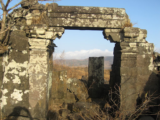
It is therefore anti-climactic that today, in all probability, all one can find are encroachers and hutments in the area. It is sad that a heritage site with such a glorious past, has been allowed to run to seed. The fort which was once visible from the Mahim Causeway and Bandra Reclamation, is barely visible now. The Mahim Fort needs to be restored and given the status of heritage structure.

A case of Mahim Fort, Mahim, Mumbai, submitted by Swetal Kanwelau of the Kamala Raheja Institute of Architecture & Environmental Studies, Mumbai, won the second prize at the Second IAHH International Student Design Competition. The results were announced in February 2004. The competition was aimed at investigating the issue of urban decay and degradation to evolve a more enlightened approach to planning, design and management of revitalisation, restructuring, redesign, conservation and redevelopment of such urban areas.

Image:Bombay map 18c.jpg


Fact File


Location: Mumbai


Distance from major cities:
Pune - 165 km


Villages at Foothills: Mahim
Altitude: Sea Level
Latitude: 19°2'31"N
Longitude: 72°50'17"E


Best time to visit: Throughout the year {mosmap lat='19.042056'|lon='72.838108'}

topHistory


In 1684, the fort was strengthened by Sir Thomas Grantham. In 1772, the Portuguese attempted to attack this fort, but
they were repelled by the British with cannon balls. The Mount Mary's Bascilica also was damaged during this encounter.
According to accounts, the fort had 100 soldiers and 30 cannons at that time.

Mahim Fort by Himanshu  Sarpotdar.

topAttractions


The fort lies off the Mahim Causeway which links the suburbs to the city. The mushrooming of slums and encroachment
around the fort has lead to it being in a dilapidated state, with cracks appearing. Tidal changes in the Mahim Creek have
also contributed to structural changes. The Bandra-Worli Sea Link poses a threat to it.

OLD SNAP >>

Mahim FORT by BOMBMAN.


<>

Trekking spot - Kalvantin DURG !!

Trekking spot - Kalvantin DURG !!


It is adjacent to Prabalgad fort. On the Mumbai Pune express highway one can take the Shedung exit. Shedung is the base villageof Prabaland Kalavantin forts. The trek is a 3 hours tiring climb from here. You need to trek up the machi and from the village on machi there are rock cut steps which lead us to the top of the fort.


The fort top commands an excellent view of the surroundings with Prabal in
the front. Matheran, Chanderi, Shrimallang, Irshal Karnala, Manikgad, etc
can be easily identified

CLOSE LOOK


<>

Trekking Spot and photos - Arnala fort

Trekking Spot and photos - Arnala fort

The fort of Arnala is built on the northeast of a small island Arnala. As river Vaitarna of North-Konkan meets the sea near this fort it is possible to keep watch on this creek and the surrounding area.

arnala by Manisha2106.


History :
Sultan Mahmood Begda of Gujarat built the sea fort of Arnala in 1516. In 1530 Portuguese won this fort and built new structures on it. Portuguese ruled over the fort for more than 200 years. Later the Marathas took it. Bajirao-I reconstructed fort like the Portuguese. In 1817, like the other forts, British captured this fort also.

Fascinating Spots :
The fort is approximately rectangular in shape and is being protected by continuous and strong ramparts having a height of about 10 meters. The bastions are in good condition even today. There are three entrances to the fort out of which the main entrance is on the north side. At both sides of this entrance there are two big bastions. On the arc of this entrance nice carvings can be seen and on both sides an elephant and a tiger are carved. These indicate the strength of the ruler of the fort. On the main entrance a lithograph is seen. From the lines of the lithograph we can understand Bajirao Peshwa reconstructed that fort. Inside a fort there are temples of ‘Tryambakeshwar’ and ‘Bhavani Mata’. In front of ‘Tryambakeshwar Mahadev’ temple is a nicely built octagonal lake. Inside the fort, wells of drinking water are available. On the way towards main entrance, there is a temple of ‘Kalikamata’.

If we see the fort from the beach we see a bastion to the left, which is apart from the fort. There is a small entrance to enter it.
It takes about half an hour to 45 minutes to see the fort completely. We can view the surroundings while walking on the strong rampart of a fort. From the projection above the main entrance we can see the fort completely.

Kali Mandir near Arnala Fort by Nagraj Salian.


Ways To Reach :
Arnala is about 10 km from Virar station on western railway route. S.T. buses and auto-rickshaws are available to reach there. After reaching the beach from Arnala village we can reach fort by commuter boat only. The boat service is available from 6 a.m. to 12:30 p.m. and from 4 p.m. to 7 p.m. It takes about 5 to 10 minutes to reach fort through the boat.

Accommodation Facility :
Not available on fort. A day is sufficient as one can see the fort completely and return by boat within 2-3 hours.

Food Facility :
Not available on the fort

Drinking Water Facility :
Water is available in the wells on fort.

Time To Reach :
About one hour from Virar

SNAPSHOTS:

Main Entrance gate of Arnala Fort


Main Entrance gate of Arnala Fort by Nagraj Salian.

Water tank at Arnala

Water tank at Arnala by Nagraj Salian.

Temple inside Arnala Fort

Temple inside Arnala Fort by Nagraj Salian.


Arnala fort ruins


Arnala fort ruins by Konkan Premi.

Separate Buruj of Arnala fort


Separate Buruj of Arnala fort by Konkan Premi.


Arnala fort Walls

Arnala fort Walls by Nagraj Salian.

Inside View of Arnala Fort


Inside View of Arnala Fort by Nagraj Salian.

Popular Posts